Until recently, going to google maps, to get a birds eye view of a location was the default option for many Permaculture Practitioners and Consultants, but the main limitation was it could not be relied upon to provide 100% up to date imagery.
And then came the boom of personal drones.
Using a drone is a great way to do mapping on a property, either contour mapping or for a water analysis map.
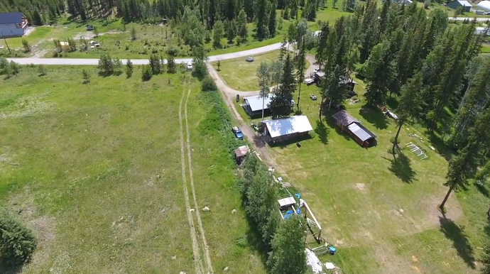
It is also a valuable tool to get a perspective on the diversity that you don’t get while surveying from a ground level and is far more complete in detail than going to satellite imagery.
Rob demonstrates, briefly, how he is getting the most from his new drone.
Recent Posts

Showing 7 comments


Hi, thanks for this video!
Are you generating the contours “from” the drone pictures ? or are you adding relief data to the map ?
If the drone does that, can you explain how ?
Thanks !
Hi Louis, the drone using photogrammetry to generate the contour lines. If you don’t have a drone, I’d recommend that you check out our latest online contour map generation tool: http://contourmapgenerator.com/
Thanks Michelle,
Nice tool thank you. Although I am looking for very accurate mapping and that’s why I am trying to do it with photogrammetry.
Can you tell more about your photogrammetry process :
What kind of flight plans, flight altitudes, photogrammetry processing software are you using ?
Maybe I could give you a quick phone call and it’ll be easier, what do you think ?
Thanks for your help
In the past we have used a drone at 80m. I use maps made easy.
Very interesting civilian science application. About time! the public (as effective land stewards) have access to a perspective and technology combining digital elevation model & aerial imagery that resource managers have been using for decades. One question Rob: does your “efficiency coefficient” you refer to in determining soil water holding capacity involve proper soil profile testing (as you know, type and properties are highly variable across a site). Thanks again for the thought provoking blog!
Jeremy,
In short yes when we need to. Profiling of the soil is the only way to get an accurate infiltration rate. We generally do this for septic system design. Most of the time we can use a ballpark figure for the feasibility work we are doing. Thanks for the question.
Good day Rob,
Are you familiar with WAM (Wet Area Mapping) being used by Alberta Forestry in what they call the “green zone”?
Might be of interest.
Dan